Follow Us x
Services: Serving Mississippi, East Mississippi, West Alabama and Central Alabama
Forest and Timber Management
Wildlife Habitat Enhancement
Timber Sales
Pay as Cut: The landowner is paid as the timber is harvested by the unit in which the timber is sold. We maintain control of the sale in order to fill a certain cash flow need by our clients, complete certain management objectives, or because we have determined with the client that this is the most profitable way to sell their timber due to market conditions.
Lump Sum: The timber is placed on the market for bid by timber buyers. The client or landowner is paid for all estimated timber on the tract at the time that the timber deed is conveyed to the buyer. The landowner loses the flexibility to make changes during the sale, however, they are paid upfront and do not have to be concerned with changing market conditions.
Reforestation Coordination
Reforestation is the reestablishment of forest cover either naturally (natural seeding, coppice, or root stock) or artificially (direct seeding or planting).
All Site Preparation Types
Site Preparation is the manipulation of a site in order to enhance the success of regeneration
- Chemical
- Mechanical
Tree Planting
-Loblolly Pine
-Longleaf Pine
-Hardwoods
-Mast Orchards (fruit tree, chestnut, sawtooth oak, etc.)
Controlled Burns
TSI (Timber Stand Improvements)
Site Preparation
Timber Appraisals
Timbers Purchase/Sale Cruises
Estate Planning and Evaluation
Property Management Plans
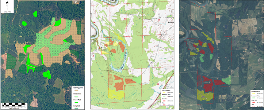
GIS and GPS Mapping Services
A geographic information system (GIS) is a system designed to capture, store, manipulate, analyze, manage, and present all types of geographical data. We are able to integrate, store, edit, analyze, share, and display geographic information for informing decision making. This enables our clients to make harvest, planting, and stand management plan changes and decisions based on a visible "blueprint" or map.
